 |
AROUND AND ABOUT Revised 1966 ITINERARY IDEAS A FEW WORDS ABOUT ROMNEY MARSH |
|||||
|
|
||||||
|
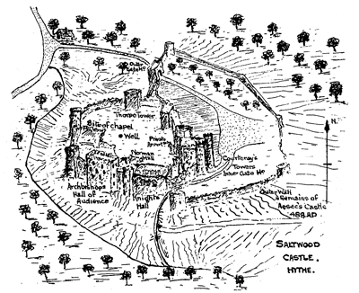
CONTENTS Marsh Frogs | Smuggling | Cinque Ports | Excursions | Dymchurch | New Romney | Hythe | Saltwood | Dungeness | Lympne | Folkestone | Dover | Canterbury | Chilham | Ashford | Appledore | Tenterden | Smallhythe | Bodiam | Battle | Winchelsea | Rye | Brookland | Lydd | References PART III II. Using the R H and D Light Railway to extend your walking radius Turn to the eastward and employing transport you can spend a very profitable day. The Romney, Hythe and Dymchurch Light Railway will drop you on the outskirts of the town along side the Royal Military Canal. A short walk from the station will lake you into civilisation and the main shopping centre. Overlooking the town on the hillside stands the ancient three-storied XIIth century church of St. Leonards. The crypt or ground, floor provides a resting place for a very large number of human bones. Gruesome as this may sound, it is of peculiar interest to note the average sizes of these, which all tend to indicate that our forebears were much smaller than we are. Further, the encrustations at the joints would infer that Rheumatism and Arthritis were both very prevalent amongst the ancients. Whilst entering the crypt from ground level and ultimately rising to the main body of the church it is possible to leave from the 2nd floor on to the hillside, so steeply does it rise and so snugly does it embrace the building. In the church are a number of features of interest and from it a magnificent view is obtained of the English Channel. A walk of about a mile and a half from Hythe brings one to the village of Saltwood with its historic castle, now a private residence. The name, as the word implies, relates to the supnK of wood for the preparation of salt. Dating from a charter of 732 by Ethelbert King of Kent the village was requested to supply 20 wagon loads of wood annually for preparing salt at the pans situated on the sea shore in the neighbourhood. Solar evaporation' being so unreliable in this country the sea water was boiled over large wood fires and the salt deposit obtained in this rather laborious and primitive fashion. Tradition has it that on the site now occupied by the imposing pile one can see today, once stood a Roman fortress. The manor at the time of Domesday was possessed by Hugo de Montfort who did much to repair and refortify the castle.
Another important person in its history is Henry de Essex, Baron of Raleigh, standard bearer to King Henry II who further improved and strengthened the fortifications. Tradition states that this Henry through an act of cowardice lost the standard in a skirmish against the Welsh in Flintshire, and though vanquished in a legal duel or combat, his life was spared by the King's clemency. Distraught with shame, he entered a monastery and took holy orders, so forfeiting his castle to the King. Archbishop Thomas a Becket however pointed out to the King that in actual fact Henry de Essex had only held the castle from the church and it was not therefore his by right of inheritance. This holy prelate appears to have been a bitter thorn in the flesh of our noble King Henry II not solely in matters spiritual but here also in matters temporal. The dispute however was not settled before that priest had been foully murdered in Canterbury Cathedral by knights who made Saltwood Castle their rendezvous before proceeding on their fateful and dastardly journey. King John did however restore the castle later to the See of Canterbury who held it until the dissolution of the monasteries. The Archbishops apparently not infrequently used the castle for their private residence as a country seat away from their ecclesiastical cares. Archbishop Courtenay, who made many improvements to the castle, has left his coat of arms over the principal entrance. The late Lady Conway, who recently owned the castle, spent much time and money in its restoration to the plan which it probably assumed in the days of King Richard II. From the castle to the Light Railway Station is a very little more than a mile, the most part of the way being down hill and a very pleasant walk. The R.H. & D. Light Railway will take you back to St. Mary's Bay. It would be wrong not to say a word about Dungeness before leaving this aspect of "What to do?" At the most southerly extremity of this part known as Denge Marsh lies Dungeness point, a bleak and windswept stretch of shingle andscrub running out to seaward and swept by a swiftly-flowing tidal current. Rising steeply out of the very deep in-shore water are pebble banks on which are drawn up many fishing boats. Scattered behind these, are numerous wooden sheds and shacks with all the tackles of the fishing industry. Recent years have seen great changes here. In 1960 a new Lighthouse of modern design was opened and commenced to operate on the site of the old fog-horn which had functioned up to this time. This took over from its older companion standing only a few hundred yards distance. The new light is fully automatic and has a powerful three kilo-watt high pressure Xenon electric are lamp. Mariners in the locality depend upon the regularity of its intermittent flashes when using it to compute the position of their vessels at night. Its brightness penetrates the darkness and is visible for many miles out to sea, radiating from its source at the top of a slender vertical column; its shape contrasting markedly with that of iis predecessor, a bulky circular tower of traditional design. Housed below the lamp on the new lighthouse is an automatic fog signal provided by a mass of loud speakers which come into action whenever the visibility becomes poor. No visitors are received within the new lighthouse but the interior of the older lighthouse may be viewed during the course of the afternoon. It is an interesting feature that at this point the sea is receding year by year whilst at so many others along the Kentish coast just the reverse is taking place. It is here that for centuries has flourished the time-honoured and thrilling practice of smuggling. On this bleak and windswept bit of coast there have always been a race of tough old fishermen whose only temporal ruler has been the elements. Other laws, though admittedly existent, have often times been conveniently forgotten or over looked when opportunity, offered for personal gain. The ancient adage still holds: "Help thyself: it he good for thee!!" The shingle and pebbles are both difficult and hard to walk upon, and the residents of this part use what are termed "Backsters." These are flat boards loosely strapped to the feet something in the manner as snow shoes are for use in the frozen North. It used to be a common sight to see rows of "backsters" lined up outside the village school when the children were at lessons. This school has since been closed and the children are now collected by 'bus and taken to Lydd. On the western side of Dungeness another new and massive structure dominates the scene. This is the Nuclear Power Station comprising several blocks. The two largest are the reactor buildings. These are inter-connected by the control block and each houses a Nuclear reactor generating the heat that will raise steam to drive the four powerful turbo-generators which are housed in a low rectangular structure on the seaward side. Over 80 million gallons of sea water are pumped hourly through the cooling system of this equipment, being discharged back into the sea after circulation. Another slab like structure to the landward side of the reactor buildings houses the switch gear and distribution equipment. From it electric cables rise to the summit of rows of pylons conducting the power into the vast network of the national grid, and providing for the requirements of millions of people. Whilst at Dungeness a visit to the Royal National Life Boat Station will probably be of interest. This is situated rather less than a mile to the northward of the lighthouse on the eastern side of the peninsula. It is possible to return from here either by the Romney, Hythe and Dymchurch Light Railway or by way of the sea shore. For juniors the journey is recommended as being performed by train in both directions. To the Northwestward of the tower in the Denge Marsh is a famous bird sanctuary where many rare birds may be seen. It is here that migratory birds congregate when on passage both southward and northward in late and early summer respectively. In the months of May and June the profusion of wild flowers growing amongst the pebbles is indeed remarkable — Vipers Bugloss, Yellow-horn Poppy and Foxglove are parti- cularly prolific at this time of the year. During 1944, the entire coastline and the hinterland, was turned into one vast 'beach-head' for the continental invasion of Europe, known to so many as "Operation Overlord." Private houses were converted into strong points, fuel tanks, pumping stations and other military headquarter installations without altering their outward appearance to the casual observer from the air. This seaside collection of bungalows, sheds and huts continued to maintain its holiday appearance, whilst in fact it housed all the most up-to-date base equipment for the most ambitious and gigantic of amphibious operations ever undertaken. From here it was that "Pluto" was run out across the Channel and the pipe lines carried petrol and oil for the use of the Allied invasion vehicles on their arrival in France. A mighty armada of craft was assembled along this shore and from here was mounted the operation which terminated Hitler's rule in Europe less than a year later. Out to sea is still to be seen part of a "Mulberry" which sank before being towed over to the French shore to form the famous artificial harbour which enabled the bridge-head to be established and maintained in Normandy; indeed a memorable feat. There is only one word of warning necessary when visiting Dungeness. Due to the swift currents and depth of water bathing is EXTREMELY DANGEROUS. In no circumstances should any one contemplate taking a welcome dip in an attractive sea on a hot afternoon.
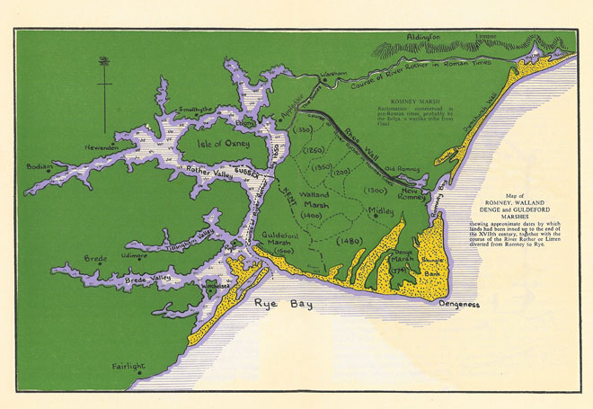
GENERAL There are many other villages of interest in the Marshes which lie scattered about with their farm buildings, churches and clusters of dwellings nestling amongst clumps of trees. To describe each would take longer than readers could spare for the study of the burning question of "what to do during our stay in foreign parts." For those interested in bird life this part of Kent provides a paradise. The lovely sight of swans flying singly or in formation is quite common. Their grace in flight for birds of such enormous size has to be seen to be appreciated. In short, for those who for one reason or another are prevented from taking more costly excursions to other places of interest in the neighbourhood the limits of shanks' pony provide adequate entertainment and valuable instructive material for any party. If you are able slightly to extend the limitations of shanks' pony by a trip or two on the Light Railway and possibly one coach ride you need never have a dull moment in the course of your stay on Romney Marsh. A Motor Coach Assisted Ramble Having now visited three extremities of the marsh it remains for a call to be paid upon the erstwhile coast line of England which now forms the northern boundary. Here flows the Royal Military Canal in peaceful beauty of perfect rural surroundings under the escarpment of the southern fringe of the North Downs. From Hythe to Appledore this waterway follows the bed of what was one of the navigable estuaries of that evasive and fickle river the Rother. Like the Martello Towers the Royal Military Canal was constructed at the end of the XVIIIth century as a defence work against the threatened invasion of Napoleon. Conjecture has done much to reconstruct the topography of this part of England which now bears so little resemblance to what it was 2,000 years ago. Harbours and ports have flourished and vanished, rivers and waterways have changed their courses many times, till today even the very name Romney Marsh would appear as a misnomer. None the less a visit to this boundary is more than worthwhile even if only to allow one's imagination to run wild and draw inspiration from nature as one walks beside the cool placid waters under the spreading branches of Alder and Hornbeam with the occasional Oak, and the Castle of Lympne on the hill above.
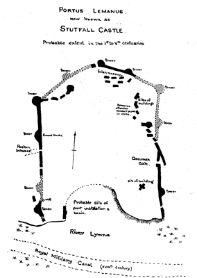
It is a romantic scene to which you are brought by motor coach, having crossed the Marsh via Dymchurch to West Hythe. Here the party de-busses and walks along the bank of the Canal for a distance of about half a mile before turning right to climb the hill passing through the ruins of the ancient Roman Castle of Stutfall, or more correctly Portus Lemanus. The Castle itself appears to have an area of about five acres. (The high road, which follows the Roman road from Canterbury goes almost straight to Lympne). Seaward you see the vast outlay of the Romney Marshes and the English Channel to the coast of France. This tract of land in times past has been subject to many geological changes, but is now thoroughly subjugated by the hand of man, and is computed to contain about 56,000 acres, including the shingle banks at Dungeness and Hythe, which may be estimated at 10,000 acres. It is intersected with dykes and roads and every part is in high cultivation as pasture or arable land, chiefly the former upon which at least 20,000 sheep are sustained, and numerous herds of cattle. The ocean itself is curbed by a strong mural defence, called the Dymchurch Wall. Immediately beneath the spot where the visitor supposedly stands was Portus Lemanus, one of the great harbours of Roman Britain, but the name and position are all that history has left of a place through which for some centuries poured a stream of communications between Britain and Gaul, and which shared with Rutupiae the honour of sheltering the Roman fleet. The port is now no more. The destruction of the fortress has been assigned to landslips to such as the coast of Kent is not infrequently subjected. Subsidences of the earth occasioned by land-springs acting upon the clay, which, being forced out from its bed, leaves the overlying sandstone without support, and in consequence, it gives way, and slides down. Some attribute its overthrow to the Saxons, but it is more likely to have been an earthquake assisted by the other two, not omitting our Danish ancestors whose savagery passes all description.
—Michael Drayton. The crenellated mansion on the brow of the hill is said to stand upon the site of a Roman Camp though little trace of this can now be found. Archbishop Lanfranc in the 11th century commenced the construction of the present house and church much of the masonry for which had been disposed from Stutfall. This is yet one more cause for ths final overthrow of the more ancient of the two fortifications. Lympne Castle is not however open to the public though a very good impression of the exterior can be had from the main gateway near the church as also from the path as it ascends the hill. The path continues up the hill through a coppice to Lympne village, re-entering the main road at the County Members Inn. From here the party re-embusses and proceeds to a point just beyond the Aldington turning where they may alight and scramble up to the Knoll whence is obtainable a wonderful panorama of the Marsh. The coast line of France is frequently visible from this spot. Here once stood Caesar's camp and from this vantage point Roman legionaries kept look-out watch across the Channel, and over the surrounding countryside. Here too in the Great War of 1939-45 was yet another observation post, used in the defence system of this Island against the threat of invasion by Hitler's hordes, and the ruthless aerial attacks which laid waste so much of our land and damaged so many towns and villages in Kent. At all times of the year this is a particularly beautiful spot and the woods that fringe it are poetically lovely in their profusion of wild flowers, especially in late spring and early summer. Here too the Nightingale sings in notes so crystal clear. It should however be born in mind that whilst access is unrestricted the property is private and accordingly demands every respect. The extent of the ramble can be arranged with the coach driver who will indicate where he will collect the party for their return run across theMarsh. The extent of walking involved is under two miles. Including as it does such a large range of subjects of historical, geographical and rural interest it is a tour for all who come to Romney Marsh and should not be missed. |
||||||